Ymele:Greater Macedonia.png
Nænig mare micelness nis brucendlicu.
Greater_Macedonia.png (400 × 338 pixela, ymelan micelness: 11 KB, MIME cynn: image/png)
Scortness
| Towritenness |
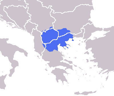
English: The modern greater Macedonian region imposed over national borders. |
| Tælmearc | |
| Fruma | media:Europe blank map.png |
| Dædfruma |
|
Leaf:
| I, the copyright holder of this work, release this work into the public domain. This applies worldwide. In some countries this may not be legally possible; if so: I grant anyone the right to use this work for any purpose, without any conditions, unless such conditions are required by law. |
Ymelan stær
Swing dæg/tide mid mys to seonne þa ymelan swa heo wæs on þære tide geywed.
| Dæg/Tid | Metungincel | Micelnesse gemetu | Brucend | Ymbspræc | |
|---|---|---|---|---|---|
| nu | 19:08, 14 Solmonað 2019 | | 400 × 338 (11 KB) | Ασμοδαίος | Reverted to version as of 16:05, 15 February 2014 (UTC) -- the Šar mountains are the modern region's boundary to the north |
| 09:06, 14 Solmonað 2019 |  | 400 × 338 (9 KB) | Skylax30 | Reverted to version as of 09:34, 15 February 2014 (UTC) | |
| 16:05, 15 Solmonað 2014 |  | 400 × 338 (11 KB) | Future Perfect at Sunrise | Reverted to version as of 11:03, 16 July 2009. New version was not what this file is meant to show. | |
| 09:34, 15 Solmonað 2014 |  | 400 × 338 (9 KB) | Stelios2267 | The true size | |
| 11:03, 16 Æfterra Liða 2009 |  | 400 × 338 (11 KB) | Cplakidas | removed weird blob in the Mediterranean | |
| 21:13, 23 Sēremōnaþ 2009 |  | 400 × 338 (11 KB) | EDG161 | {{Information |Description={{en|1=The modern greater Macedonian region imposed over national borders.}} |Source=Europe blank map.png |Author=Original work: User:Wiki-vr Derivative work: EDG161 |Date=2009-06-23 |Permission= |other_v |
Biliþbendas
Þā folgendan trametas bindaþ tō þissum biliðe:
Ymelan eormen nytt
Þas wiki brucaþ þissa ymelena:
- Nytt on af.wiki.x.io
- Nytt on ar.wiki.x.io
- Nytt on az.wiki.x.io
- Nytt on bs.wiki.x.io
- Nytt on ca.wiki.x.io
- Nytt on cs.wiki.x.io
- Nytt on da.wiki.x.io
- Nytt on de.wiki.x.io
- Nytt on el.wiki.x.io
- Nytt on en.wiki.x.io
- Macedonia (region)
- Vardar Macedonia
- Demographic history of Macedonia
- Macedonian Struggle
- Category:Wikipedians in North Macedonia
- User:Revizionist
- Template:User Macedonian
- Category:American people of Macedonian descent
- User:AirKoryoTU-204
- Category:Wikipedians interested in North Macedonia
- Category:WikiProject North Macedonia participants
- User:Dynamic09
- Template:Portal/doc/all
- User:Phill24th/Memoshi
- Category:1990s disestablishments in the Republic of Macedonia
- Ljupčo Malinkov
- Wikipedia:Userboxes/Location/North Macedonia
- User talk:Buaidh/Archive 2019
- Template:User North Macedonia/cat
- Category:Macedonian Wikipedians
- Template:User North Macedonia/boxes
- Karl Novelich
- Lev Glavinchev
- Category:Macedonian women poets
- Category:Macedonian women scientists
- User:Vikipisatelj
- User:Luis Trexxxx
- Slobodan Unkovski
- User:Falcaorib/Bulgaria and North Macedonia
- User:Stevo Pendarovski
- User:MKDigitalized
- Category:Macedonian jazz pianists
- Srebra Apostolova
- Nytt on eo.wiki.x.io
- Nytt on es.wiki.x.io
View more global usage of this file.