Ymele:Moll - A Map of the West-Indies.png

Micelness þisre forebysene: 793 be 599 dotta. Oðra metinga brædo: 318 be 240 dotta | 635 be 480 dotta | 1,016 be 768 dotta | 1,200 be 907 dotta.
Frumlicu ymele (1,200 × 907 pixela, ymelan micelness: 2.32 MB, MIME cynn: image/png)
Scortness
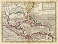
Herman Moll: A Map of the West-Indies, 1736
| Herman Moll
(1654–1732) |
|||
|---|---|---|---|
 |
|||
| Alternative names |
Moll, Hermann | ||
| Description | British cartographer, engraver and publisher | ||
| Date of birth/death | circa 1654 |
22 Haligmonað 1732 | |
| Location of birth/death | Unknown place |
Lunden | |
| Work location | |||
| Authority file | |||
Leaf:
-
 lower resolution
 -
 higher resolution

.jpg)
|
This work is in the public domain in its country of origin and other countries and areas where the copyright term is the author's life plus 100 years or fewer. | |
| This file has been identified as being free of known restrictions under copyright law, including all related and neighboring rights. | |
Ymelan stær
Swing dæg/tide mid mys to seonne þa ymelan swa heo wæs on þære tide geywed.
| Dæg/Tid | Metungincel | Micelnesse gemetu | Brucend | Ymbspræc | |
|---|---|---|---|---|---|
| nu | 17:02, 13 Haligmonað 2005 | | 1,200 × 907 (2.32 MB) | Frank Schulenburg | Herman Moll: ''A Map of the West-Indies'', 1736 {{Creator:Herman Moll}} Category:18th century maps |
Biliþbendas
Þā folgendan trametas bindaþ tō þissum biliðe:
Ymelan eormen nytt
Þas wiki brucaþ þissa ymelena:
- Nytt on af.wiki.x.io
- Nytt on ar.wiki.x.io
- Nytt on br.wiki.x.io
- Nytt on ca.wiki.x.io
- Nytt on cs.wiki.x.io
- Nytt on da.wiki.x.io
- Nytt on de.wiki.x.io
- Nytt on en.wiki.x.io
- Nytt on es.wiki.x.io
- Nytt on eu.wiki.x.io
- Nytt on frr.wiki.x.io
- Nytt on fr.wiki.x.io
- Nytt on ga.wiki.x.io
- Nytt on he.wiki.x.io
- Nytt on hr.wiki.x.io
- Nytt on ht.wiki.x.io
- Nytt on hy.wiki.x.io
- Nytt on it.wiki.x.io
- Nytt on la.wiki.x.io
- Nytt on lt.wiki.x.io
- Nytt on mk.wiki.x.io
- Nytt on mt.wiki.x.io
- Nytt on nl.wiki.x.io
View more global usage of this file.